
Make a donation
Gear up for your next adventure:
As an Amazon Associate, this site earns from qualifying purchases at no extra cost to you.
Castor topographic map
Click on the map to display elevation.
Make a donation
Gear up for your next adventure:
As an Amazon Associate, this site earns from qualifying purchases at no extra cost to you.
Castor
Castor (Italian: Castore) is a mountain in the Pennine Alps on the border between Valais, Switzerland and the Aosta Valley in Italy. It is the higher of a pair of twin peaks (German: Zwillinge), the other being Pollux, named after the Gemini twins of Roman mythology. Castor's peak is at an elevation of 4,225 m (13,862 ft), and it lies between Breithorn and the Monte Rosa. It is separated from Pollux by a pass at 3,847 m (12,621 ft), named Passo di Verra in Italian and Zwillingsjoch in German.
Make a donation
Gear up for your next adventure:
As an Amazon Associate, this site earns from qualifying purchases at no extra cost to you.
About this map
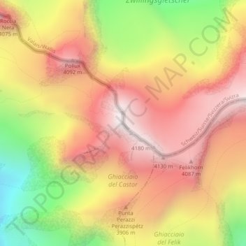
Name: Castor topographic map, elevation, terrain.
Location: Castor, Ayas, Aosta Valley, 11020, Italy (45.92080 7.79322 45.92090 7.79332)
Average elevation: 3,721 m
Minimum elevation: 3,078 m
Maximum elevation: 4,184 m
Make a donation
Gear up for your next adventure:
As an Amazon Associate, this site earns from qualifying purchases at no extra cost to you.