Geolocate

South Ronaldsay topographic map

Interactive map

Click on the map to display elevation.
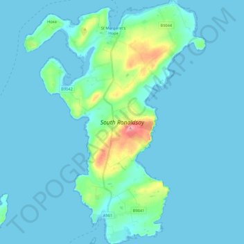
South Ronaldsay

The cardinal points of the island are Ayre of Cara, by Churchill Barrier no. 4 (north), Grimness (east), Brough Ness, (south) and Hoxa Head, (west). The highest elevation is Ward Hill, which reaches 118 metres (387 ft). This name is common one in Orkney for the highest point on an island and comes from the historic use of these places used for the lighting of warning beacons.

Wikipedia (CC-BY-SA 3.0)

About this map

Name: South Ronaldsay topographic map, elevation, terrain.

Location: South Ronaldsay, Orkney Islands, Scotland, United Kingdom (58.72958 -3.03671 58.83941 -2.87783)

Average elevation: 12 m

Minimum elevation: -1 m

Maximum elevation: 118 m

Orkney Islands trails, hiking, mountain biking, running and outdoor activities

Other topographic maps

Click on a map to view its topography, its elevation and its terrain.

Twatt

United Kingdom > Scotland > Orkney Islands

Average elevation: 33 m

Hoxa

United Kingdom > Scotland > Orkney Islands

Average elevation: 6 m

Sandwick

United Kingdom > Scotland > Orkney Islands

Average elevation: 29 m

Skara Brae

United Kingdom > Scotland > Orkney Islands

Average elevation: 15 m

Tankerness

United Kingdom > Scotland > Orkney Islands

Average elevation: 16 m

Balfour

United Kingdom > Scotland > Orkney Islands

Average elevation: 9 m

Finstown

United Kingdom > Scotland > Orkney Islands

Average elevation: 48 m

Skelwick

United Kingdom > Scotland > Orkney Islands

Average elevation: 11 m

Scapa Flow

United Kingdom > Scotland > Orkney Islands

Average elevation: 14 m

Stromness

United Kingdom > Scotland > Orkney Islands

Average elevation: 21 m

Eynhallow

United Kingdom > Scotland > Orkney Islands

Average elevation: 2 m

Pierowall

United Kingdom > Scotland > Orkney Islands

Average elevation: 20 m

Egilsay

United Kingdom > Scotland > Orkney Islands

Average elevation: 4 m

Lyness

United Kingdom > Scotland > Orkney Islands

Average elevation: 28 m

Midbea

United Kingdom > Scotland > Orkney Islands

Average elevation: 25 m

Hackness

United Kingdom > Scotland > Orkney Islands

Average elevation: 7 m

Stenness

United Kingdom > Scotland > Orkney Islands

Average elevation: 27 m

Orphir

United Kingdom > Scotland > Orkney Islands

Average elevation: 64 m

Kirkwall

United Kingdom > Scotland > Orkney Islands

Average elevation: 27 m

Longhope

United Kingdom > Scotland > Orkney Islands

Average elevation: 17 m

Kirkwall

United Kingdom > Scotland > Orkney Islands

Average elevation: 27 m

Wyre

United Kingdom > Scotland > Orkney Islands > The Brinian

Average elevation: 5 m

Kirkwall

United Kingdom > Scotland > Orkney Islands

Average elevation: 27 m

Quoyloo

United Kingdom > Scotland > Orkney Islands > Quoyloo

Average elevation: 36 m