
Make a donation
Gear up for your next adventure:
As an Amazon Associate, this site earns from qualifying purchases at no extra cost to you.
Mandeville topographic map
Click on the map to display elevation.
Make a donation
Gear up for your next adventure:
As an Amazon Associate, this site earns from qualifying purchases at no extra cost to you.
About this map
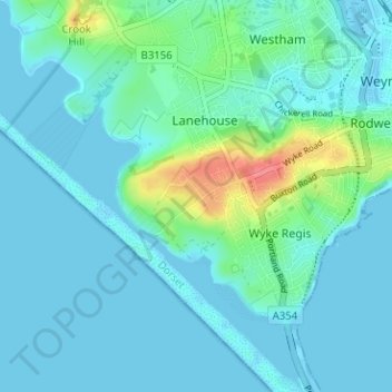
Name: Mandeville topographic map, elevation, terrain.
Average elevation: 11 m
Minimum elevation: -5 m
Maximum elevation: 67 m
Dorset trails, hiking, mountain biking, running and outdoor activities
Make a donation
Gear up for your next adventure:
As an Amazon Associate, this site earns from qualifying purchases at no extra cost to you.
Other topographic maps
Click on a map to view its topography, its elevation and its terrain.
Isle of Portland
United Kingdom > England > Dorset > Wyke Regis
In Museums Without Walls, Jonathan Meades declares that "Portland is a bulky chunk of geological, social, topographical and demographic weirdness. It is the obverse of a beauty spot. 'Beauty' in this construction implies the picturesque. Portland is gloriously bereft of this quality. It is awesome. There is…
Average elevation: 11 m