
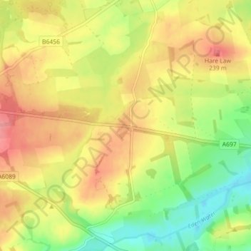
Houndslow topographic map
Interactive map
Click on the map to display elevation.
About this map
Name: Houndslow topographic map, elevation, terrain.
Location: Houndslow, Scottish Borders, Scotland, TD3 6LX, United Kingdom (55.69755 -2.61014 55.73755 -2.57014)
Average elevation: 208 m
Minimum elevation: 164 m
Maximum elevation: 247 m
Other topographic maps
Click on a map to view its topography, its elevation and its terrain.
Denholm
United Kingdom > Scotland > Scottish Borders
In Main Street, stands The Text House, a category B listed building, erected about 1910 by John Haddon (1845–1924), a medical doctor and author of published works on public sanitation and dietetics. The 3-storey house is in the arts and craft style. One of the texts on the front elevation is a reminder to…
Average elevation: 128 m
Greenknowe Tower
United Kingdom > Scotland > Scottish Borders > Gordon > Nether Huntlywood
Average elevation: 157 m
Easter Wooden Farm
United Kingdom > Scotland > Scottish Borders > Easter Wooden Farm
Average elevation: 109 m
Curling Pond
United Kingdom > Scotland > Scottish Borders > Earlston > Georgefield
Average elevation: 153 m