Geolocate

6 topographic map

Click on the map to display elevation.

About this map

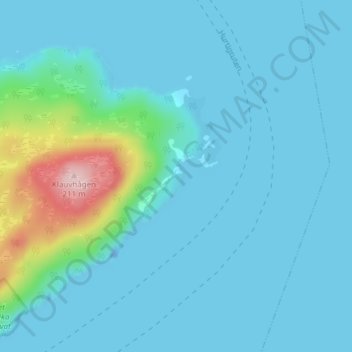
Name: 6 topographic map, elevation, terrain.

Location: 6, Klauva, Senja, Troms, 9300, Norway (69.18016 17.98967 69.20016 18.00967)

Average elevation: 25 m

Minimum elevation: -24 m

Maximum elevation: 204 m

Gear up for your next adventure:

📢Survival Whistles - Essential safety gear for signaling for help in mountain fog
🔋Rechargeable Batteries - Eco-friendly power for headlamps and older GPS units
🧭Professional Hiking Compasses - High-precision liquid-filled compasses for map reading and orientation
🥾Trekking Poles - Poles to improve stability on uneven terrain
Lightweight Solo Tents - Backpacking tents designed for wild camping in the UK highlands

As an Amazon Associate, this site earns from qualifying purchases at no extra cost to you.