
Ponferrada topographic map
Interactive map
Click on the map to display elevation.
About this map
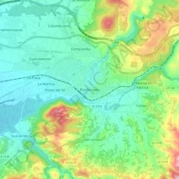
Name: Ponferrada topographic map, elevation, terrain.
Average elevation: 584 m
Minimum elevation: 476 m
Maximum elevation: 857 m
Die Stadt Ponferrada liegt am Zusammenfluss von Sil und Boeza in der hügeligen bis gebirgigen Landschaft des Bierzo knapp 115 km (Fahrtstrecke) westlich der Provinzhauptstadt León auf etwa 510 m Höhe. Das Klima ist gemäßigt bis warm; Regen (ca. 650 mm/Jahr) fällt überwiegend im Winterhalbjahr.