
Calne topographic map
Click on the map to display elevation.
About this map
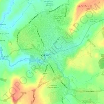
Name: Calne topographic map, elevation, terrain.
Location: Calne, Wiltshire, England, United Kingdom (51.42183 -2.01957 51.45594 -1.97488)
Average elevation: 86 m
Minimum elevation: 59 m
Maximum elevation: 121 m
Wiltshire trails, hiking, mountain biking, running and outdoor activities
Other topographic maps
Click on a map to view its topography, its elevation and its terrain.
Cley Hill
United Kingdom > England > Wiltshire
Cley Hill (grid reference ST838449) is a prominent hill to the west of Warminster in Wiltshire, England. Its summit has a commanding view of the Wiltshire / Somerset county boundary, at 244 metres (801 ft) elevation. The land is in Corsley parish and is owned by the National Trust.
Average elevation: 157 m