
Beebe topographic map
Click on the map to display elevation.
About this map
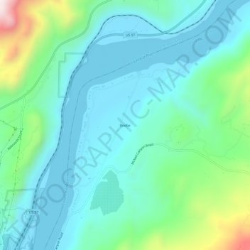
Name: Beebe topographic map, elevation, terrain.
Location: Beebe, Douglas County, Washington, United States (47.82047 -119.96921 47.86047 -119.92921)
Average elevation: 370 m
Minimum elevation: 214 m
Maximum elevation: 959 m
Other topographic maps
Click on a map to view its topography, its elevation and its terrain.
Waterville
United States > Washington > Douglas County
Waterville occupies a high, open position on the Waterville Plateau in central Douglas County, at about 2,622 feet (799 m) above sea level, where the town sits amid broad upland farmland rather than in a river valley. The surrounding terrain is gently rolling to moderately undulating, with shallow draws, low…
Average elevation: 807 m
Moses Coulee
United States > Washington > Douglas County
Pleistocene glaciers advanced onto the Waterville Plateau, with the Okanogan Lobe of the Cordilleran Ice Sheet reaching as far south as the town of Withrow. Evidence for glaciation on the Waterville Plateau includes polished and striated bedrock, glacial erratics, drumlinoid topography, eskers, moraines,…
Average elevation: 666 m