

Make a donation
Gear up for your next adventure:
As an Amazon Associate, this site earns from qualifying purchases at no extra cost to you.
Moses Coulee topographic map
Click on the map to display elevation.
Make a donation
Gear up for your next adventure:
As an Amazon Associate, this site earns from qualifying purchases at no extra cost to you.
Moses Coulee
Pleistocene glaciers advanced onto the Waterville Plateau, with the Okanogan Lobe of the Cordilleran Ice Sheet reaching as far south as the town of Withrow. Evidence for glaciation on the Waterville Plateau includes polished and striated bedrock, glacial erratics, drumlinoid topography, eskers, moraines, meltwater channels, and glacial till. The Withrow Moraine complex marks the maximum southern extent of the Okanogan Lobe, and a series of recessional moraine complexes represent retreating ice margins. Ice damming of the Columbia River formed Glacial Lake Columbia and Lake Spokane, larger lakes than Lake Roosevelt, which is currently backed up in the same location behind the Grand Coulee Dam.
Make a donation
Gear up for your next adventure:
As an Amazon Associate, this site earns from qualifying purchases at no extra cost to you.
About this map
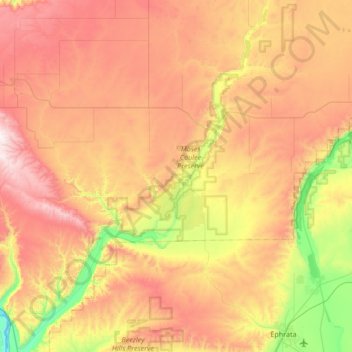
Name: Moses Coulee topographic map, elevation, terrain.
Location: Moses Coulee, Douglas County, Washington, United States (47.29413 -120.05919 47.75165 -119.58129)
Average elevation: 666 m
Minimum elevation: 172 m
Maximum elevation: 1,219 m
Make a donation
Gear up for your next adventure:
As an Amazon Associate, this site earns from qualifying purchases at no extra cost to you.
Other topographic maps
Click on a map to view its topography, its elevation and its terrain.
Waterville
United States > Washington > Douglas County
At 2,625 ft (800 m), Waterville has the highest elevation of any incorporated city or town in Washington.
Average elevation: 807 m
Make a donation
Gear up for your next adventure:
As an Amazon Associate, this site earns from qualifying purchases at no extra cost to you.
Make a donation
Gear up for your next adventure:
As an Amazon Associate, this site earns from qualifying purchases at no extra cost to you.
Make a donation
Gear up for your next adventure:
As an Amazon Associate, this site earns from qualifying purchases at no extra cost to you.