
Make a donation
Gear up for your next adventure:
As an Amazon Associate, this site earns from qualifying purchases at no extra cost to you.
Shahr-e Kord topographic map
Click on the map to display elevation.
Make a donation
Gear up for your next adventure:
As an Amazon Associate, this site earns from qualifying purchases at no extra cost to you.
Shahr-e Kord
Shahr-e Kord is located about 90 km (56 mi) southwest of Isfahan and 512 km (318 mi) of Tehran. It is topographically situated in the north of the Zagros Mountains. Being located 2,070 m (6,790 ft) above the sea level, Shahr-e Kord is the most elevated among the centers of the provinces of Iran, known as the Roof of Iran.
Make a donation
Gear up for your next adventure:
As an Amazon Associate, this site earns from qualifying purchases at no extra cost to you.
About this map
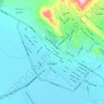
Name: Shahr-e Kord topographic map, elevation, terrain.
Average elevation: 2,102 m
Minimum elevation: 2,042 m
Maximum elevation: 2,492 m
Make a donation
Gear up for your next adventure:
As an Amazon Associate, this site earns from qualifying purchases at no extra cost to you.
Other topographic maps
Click on a map to view its topography, its elevation and its terrain.
Shohada Square
Iran > Chaharmahal and Bakhtiyari Province > Sharekurd County > Shahr-e Kord
Average elevation: 2,054 m