Geolocate

Ferrara topographic map

Click on the map to display elevation.

About this map

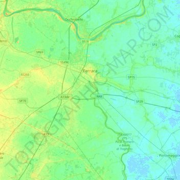
Name: Ferrara topographic map, elevation, terrain.

Location: Ferrara, Emilia-Romagna, 44121-44124, Italy (44.67343 11.46306 44.93771 11.87702)

Average elevation: 7 m

Minimum elevation: -2 m

Maximum elevation: 22 m

Other topographic maps

Click on a map to view its topography, its elevation and its terrain.

Lido delle Nazioni

Italy > Emilia-Romagna > Ferrara > Comacchio

Average elevation: -1 m

Gear up for your next adventure:

📷Outdoor Action Cameras - Cameras designed for hiking and adventure
📱Phone Mounts for Hiking - Secure mounts to carry your phone on trails
🧭Orienteering Compasses - Accurate compasses for map-based navigation
📻Hand-Crank Emergency Radios - Stay updated on weather warnings in remote areas
🧦Merino Wool Hiking Socks - Moisture-wicking socks to prevent blisters during long mountain walks

As an Amazon Associate, this site earns from qualifying purchases at no extra cost to you.