
Thank you for supporting this site ❤️
Make a donation
Make a donation
Gear up for your next adventure:
As an Amazon Associate, this site earns from qualifying purchases at no extra cost to you.
Solivo topographic map
Click on the map to display elevation.
Thank you for supporting this site ❤️
Make a donation
Make a donation
Gear up for your next adventure:
As an Amazon Associate, this site earns from qualifying purchases at no extra cost to you.
About this map
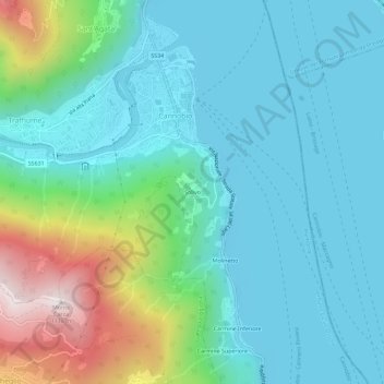
Name: Solivo topographic map, elevation, terrain.
Location: Solivo, Cannobio, Verbano-Cusio-Ossola, Piedmont, 28822, Italy (46.03382 8.68020 46.07382 8.72020)
Average elevation: 383 m
Minimum elevation: 185 m
Maximum elevation: 1,099 m
Thank you for supporting this site ❤️
Make a donation
Make a donation
Gear up for your next adventure:
As an Amazon Associate, this site earns from qualifying purchases at no extra cost to you.