
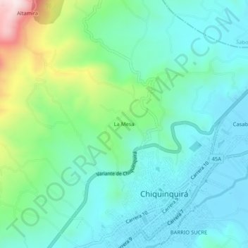
La Mesa topographic map
Interactive map
Click on the map to display elevation.
About this map
Name: La Mesa topographic map, elevation, terrain.
Average elevation: 2,667 m
Minimum elevation: 2,538 m
Maximum elevation: 3,089 m
Other topographic maps
Click on a map to view its topography, its elevation and its terrain.
Chiquinquirá
Colombia > Boyacá > Chiquinquirá > Chiquinquirá
Chiquinquirá, Occidente, Boyacá, Región Andina, 154640, Colombia
Average elevation: 2,655 m