Geolocate

Karimala topographic map

Interactive map

Click on the map to display elevation.

About this map

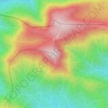
Name: Karimala topographic map, elevation, terrain.

Location: Karimala, Mananthavady, Wayanad District, Kerala, India (11.93413 75.93655 11.93423 75.93665)

Average elevation: 1,324 m

Minimum elevation: 1,058 m

Maximum elevation: 1,584 m

Other topographic maps

Click on a map to view its topography, its elevation and its terrain.

Palvelicham

India > Kerala > Mananthavady

Palvelicham, Mananthavady, Wayanad District, Kerala, India

Average elevation: 735 m

Dwaraka

India > Kerala > Mananthavady

Dwaraka, Mananthavady, Wayanad District, Kerala, 670732, India

Average elevation: 746 m

Thirunelli

India > Kerala > Mananthavady

Thirunelli, Mananthavady, Wayanad District, Kerala, India

Average elevation: 969 m

Anjukunnu

India > Kerala > Mananthavady

Anjukunnu, Mananthavady, Wayanad, Kerala, 670732, India

Average elevation: 745 m

Kattimoola

India > Kerala > Mananthavady

Kattimoola, Mananthavady, Wayanad, Kerala, 670644, India

Average elevation: 753 m

nedumblassery colony

India > Kerala > Mananthavady

nedumblassery colony, Mananthavady, Wayanad District, Kerala, 670731, India

Average elevation: 758 m

Panamaram

India > Kerala > Mananthavady > Panamaram

Panamaram, Mananthavady, Wayanad, Kerala, 670721, India

Average elevation: 736 m

Thavinhal

India > Kerala > Mananthavady > Boy's Town

Thavinhal, Boy's Town, Mananthavady, Wayanad, Kerala, India

Average elevation: 690 m