Geolocate

Redden topographic map

Click on the map to display elevation.

About this map

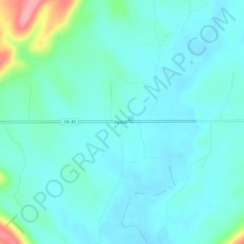
Name: Redden topographic map, elevation, terrain.

Location: Redden, Atoka County, Oklahoma, United States (34.48649 -95.86471 34.52649 -95.82471)

Average elevation: 220 m

Minimum elevation: 200 m

Maximum elevation: 314 m

Gear up for your next adventure:

🥾Hiking Boots - Waterproof and durable boots for long-distance hiking in the UK
👟Men's Trail Running Shoes - Lightweight grip for fast movement over topographic contours
🔋Power Banks - Portable chargers for long outdoor trips
🥤Collapsible Water Bottles - Save space in your rucksack as you consume your water
🛌Sleeping Mats - Insulated mats for comfortable outdoor sleeping

As an Amazon Associate, this site earns from qualifying purchases at no extra cost to you.