
Quarrington topographic map
Click on the map to display elevation.
Quarrington
According to the Köppen classification, the British Isles experience a maritime climate characterised by relatively cool summers and mild winters. Lincolnshire's position on the east of the Isles allows for a sunnier and warmer climate relative to the national average, and it is one of the driest counties in the United Kingdom. Although it may vary depending on altitude and proximity to the coast, the mean average temperature for the East of England is approximately 9 °C to 10.5 °C; the highest temperature recorded in the region was 37.3 °C at Cavendish on 10 August 2003. On average, the region experiences 30 days of rainfall in winter and 25 in summer, with 15 days of thunder and 6–8 days of hail per year; on 25 August 2001, hail the size of golf balls were reported in Sleaford and other parts of central Lincolnshire. Wind tends to affect the north and west of the country more than the East, and Lincolnshire tends to receive no more than 2 days of gale per year (where gale is a gust of wind at >34 knots, sustained for at least 10 minutes). Despite this, tornadoes form more often in the East of England than elsewhere in the country; Sleaford experienced tornadoes in 2006 and 2012, both of which caused damage to property.
About this map
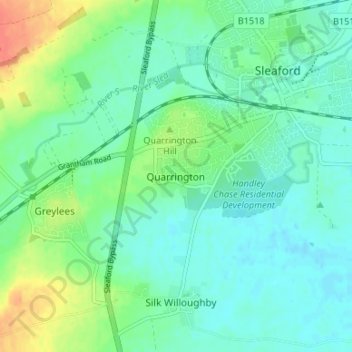
Name: Quarrington topographic map, elevation, terrain.
Average elevation: 21 m
Minimum elevation: 8 m
Maximum elevation: 53 m
Lincolnshire trails, hiking, mountain biking, running and outdoor activities
Other topographic maps
Click on a map to view its topography, its elevation and its terrain.
Washingborough
United Kingdom > England > Lincolnshire > North Kesteven > Washingborough
Average elevation: 20 m
Carlton-le-Moorland
United Kingdom > England > Lincolnshire > North Kesteven > Carlton le Moorland
Average elevation: 13 m
Threekingham
United Kingdom > England > Lincolnshire > North Kesteven > Threekingham
Average elevation: 30 m
South Hykeham
United Kingdom > England > Lincolnshire > North Kesteven > Hykeham Moor
Average elevation: 11 m
Sleaford
United Kingdom > England > Lincolnshire > North Kesteven
Although hardly damaged in the First and Second World Wars, Sleaford has close links with the Royal Air Force due to proximity to several RAF bases, including RAF Cranwell and RAF Waddington. Lincolnshire's topography – flat and open countryside – and its location in the east of the country made it ideal…
Average elevation: 18 m
Leadenham
United Kingdom > England > Lincolnshire > North Kesteven > Leadenham
Average elevation: 36 m
Osbournby
United Kingdom > England > Lincolnshire > North Kesteven > Osbournby
Average elevation: 23 m
Thorpe on the Hill
United Kingdom > England > Lincolnshire > North Kesteven > Thorpe on the Hill
Average elevation: 17 m
Billinghay
United Kingdom > England > Lincolnshire > North Kesteven
The settlement is mentioned in the Domesday Book. The name originates from a Saxon name for a fishery. The topography in ancient times would have been that of a small settlement on a gravel mound surrounded by marsh which was flooded in winter. After the draining of the fens in the late 18th century the area…
Average elevation: 4 m
North Scarle
United Kingdom > England > Lincolnshire > North Kesteven > North Scarle
Average elevation: 10 m
South Rauceby
United Kingdom > England > Lincolnshire > North Kesteven > South Rauceby
Average elevation: 47 m
Silk Willoughby
United Kingdom > England > Lincolnshire > North Kesteven > Silk Willoughby
Average elevation: 22 m
South Kyme
United Kingdom > England > Lincolnshire > North Kesteven > South Kyme
Average elevation: 3 m
Threekingham
United Kingdom > England > Lincolnshire > North Kesteven > Threekingham
Average elevation: 22 m
Kirkby la Thorpe
United Kingdom > England > Lincolnshire > North Kesteven > Kirkby la Thorpe
Average elevation: 12 m
Washingborough
United Kingdom > England > Lincolnshire > North Kesteven > Washingborough
Average elevation: 33 m
North Kyme
United Kingdom > England > Lincolnshire > North Kesteven > North Kyme
Average elevation: 4 m
Leasingham
United Kingdom > England > Lincolnshire > North Kesteven > Leasingham
Average elevation: 26 m
Witham St. Hughs
United Kingdom > England > Lincolnshire > North Kesteven > Witham St Hughs
Average elevation: 17 m
Beckingham
United Kingdom > England > Lincolnshire > North Kesteven > Beckingham
Average elevation: 16 m
Waddington
United Kingdom > England > Lincolnshire > North Kesteven
During the Ice Age, most of the region surrounding Waddington was covered by ice sheets and this has influenced the topography and nature of the soils. Waddington's cliff-top position means it is 226 ft (69 m) above sea level, giving it commanding views over the River Witham valley.
Average elevation: 47 m
Long Holt Wood
United Kingdom > England > Lincolnshire > North Kesteven > Nocton
Average elevation: 20 m
Heighington
United Kingdom > England > Lincolnshire > North Kesteven > Heighington
Average elevation: 18 m
Sleaford
United Kingdom > England > Lincolnshire > North Kesteven > Quarrington
The town centre lies about 49 feet (15 m) above sea level and has formed around the River Slea, which runs west to north-east through it. A band of Jurassic Cornbrash limestone forms the bedrock under Holdingham (where the ground rises to 82 feet (25 m) above sea level in places), parts of central Sleaford,…
Average elevation: 18 m
Scredington
United Kingdom > England > Lincolnshire > North Kesteven > Scredington
Average elevation: 13 m
Thorpe on the Hill
United Kingdom > England > Lincolnshire > North Kesteven > Thorpe on the Hill
Average elevation: 17 m
Scredington
United Kingdom > England > Lincolnshire > North Kesteven > Scredington
Average elevation: 13 m