Geolocate

Gemeinde Straß im Straßertale topographic map

Interactive map

Click on the map to display elevation.

About this map

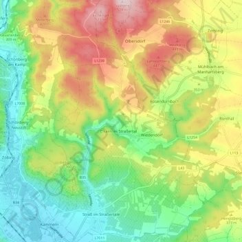
Name: Gemeinde Straß im Straßertale topographic map, elevation, terrain.

Location: Gemeinde Straß im Straßertale, Bezirk Krems, Lower Austria, 3491, Austria (48.46291 15.71143 48.53940 15.78389)

Average elevation: 331 m

Minimum elevation: 200 m

Maximum elevation: 522 m

Other topographic maps

Click on a map to view its topography, its elevation and its terrain.

Loiwein

Austria > Lower Austria > Bezirk Krems > Gemeinde Lichtenau im Waldviertel

Loiwein, Gemeinde Lichtenau im Waldviertel, Bezirk Krems, Lower Austria, 3522, Austria

Average elevation: 552 m

Gemeinde Dürnstein

Austria > Lower Austria > Bezirk Krems

Gemeinde Dürnstein, Bezirk Krems, Lower Austria, 3601, Austria

Average elevation: 382 m

Wachau Cultural Landscape

Austria > Lower Austria > Bezirk Krems

Wachau Cultural Landscape, Bezirk Krems, Lower Austria, Austria

Average elevation: 486 m