
Norton topographic map
Interactive map
Click on the map to display elevation.
About this map
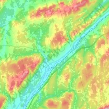
Name: Norton topographic map, elevation, terrain.
Location: Norton, Norton Parish, Kings County, New Brunswick, Canada (45.59942 -65.81683 45.70257 -65.64510)
Average elevation: 87 m
Minimum elevation: 0 m
Maximum elevation: 226 m
Other topographic maps
Click on a map to view its topography, its elevation and its terrain.
Kennebecasis River
Canada > New Brunswick > Kings County > Norton
Kennebecasis River, Norton, Norton Parish, Kings County, New Brunswick, E4E 3E1, Canada
Average elevation: 110 m