
Bat de Haü topographic map
Interactive map
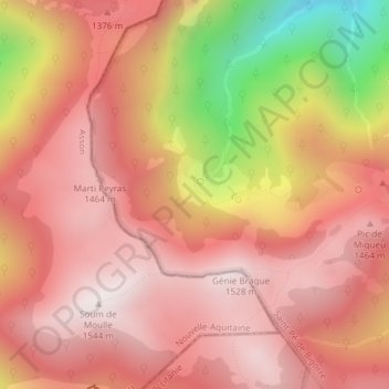
Click on the map to display elevation.
About this map
Name: Bat de Haü topographic map, elevation, terrain.
Average elevation: 1,245 m
Minimum elevation: 610 m
Maximum elevation: 1,540 m
Other topographic maps
Click on a map to view its topography, its elevation and its terrain.
Carté
France > Occitanie > Hautes-Pyrénées > Saint-Pé-de-Bigorre > Camp de Seissillou
Carté, Camp de Seissillou, Saint-Pé-de-Bigorre, Argelès-Gazost, Hautes-Pyrénées, Occitanie, France métropolitaine, 65270, France
Average elevation: 422 m
Bout du Pont
France > Occitanie > Hautes-Pyrénées > Saint-Pé-de-Bigorre
Bout du Pont, Saint-Pé-de-Bigorre, Argelès-Gazost, Hautes-Pyrénées, Occitanie, France métropolitaine, 65270, France
Average elevation: 503 m