
Breil/Brigels topographic map
Interactive map
Click on the map to display elevation.
About this map
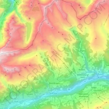
Name: Breil/Brigels topographic map, elevation, terrain.
Location: Breil/Brigels, Surselva, Grisons, Switzerland (46.73396 8.95708 46.87521 9.14025)
Average elevation: 1,885 m
Minimum elevation: 716 m
Maximum elevation: 3,366 m
Other topographic maps
Click on a map to view its topography, its elevation and its terrain.
Lake Toma
Switzerland > Grisons > Surselva > Tujetsch
Lake Toma, Tujetsch, Surselva, Grisons, Switzerland
Average elevation: 2,390 m
Medel (Lucmagn)
Switzerland > Grisons > Surselva
Medel (Lucmagn), Surselva, Grisons, Switzerland
Average elevation: 2,100 m
Vals
Switzerland > Grisons > Surselva
Vals, Surselva, Grisons, 7132, Switzerland
Average elevation: 2,177 m
Soladüra
Switzerland > Grisons > Surselva > Vals
Soladüra, Vals, Surselva, Grisons, 7132, Switzerland
Average elevation: 1,806 m
Tujetsch
Switzerland > Grisons > Surselva
Tujetsch, Surselva, Grisons, Switzerland
Average elevation: 2,147 m