Rubengera topographic map
Interactive map
Click on the map to display elevation.
About this map
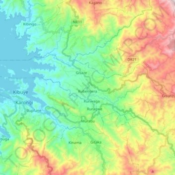
Name: Rubengera topographic map, elevation, terrain.
Location: Rubengera, Karongi, Western Province, Rwanda (-2.08678 29.31788 -2.02588 29.48153)
Average elevation: 1,830 m
Minimum elevation: 1,453 m
Maximum elevation: 2,614 m
Other topographic maps
Click on a map to view its topography, its elevation and its terrain.
Bwishyura
Rwanda > Western Province > Karongi
Bwishyura, Karongi, Western Province, Rwanda
Average elevation: 1,711 m
Mubuga
Rwanda > Western Province > Karongi > Mubuga
Mubuga, Karongi, Western Province, Rwanda
Average elevation: 1,607 m