
Make a donation
Gear up for your next adventure:
As an Amazon Associate, this site earns from qualifying purchases at no extra cost to you.
Doha topographic map
Click on the map to display elevation.
Make a donation
Gear up for your next adventure:
As an Amazon Associate, this site earns from qualifying purchases at no extra cost to you.
Doha
Doha is located on the central-east portion of Qatar, bordered by the Persian Gulf on its coast. Its elevation is 10 m (33 ft). Doha is highly urbanized. Land reclamation off the coast has added 400 hectares of land and 30 km (19 mi) of coastline. Half of the 22 km2 (8.5 sq mi) of surface area which Hamad International Airport was constructed on was reclaimed land. The geology of Doha is primarily composed of weathered unconformity on the top of the Eocene period Dammam Formation, forming dolomitic limestone.
Make a donation
Gear up for your next adventure:
As an Amazon Associate, this site earns from qualifying purchases at no extra cost to you.
About this map
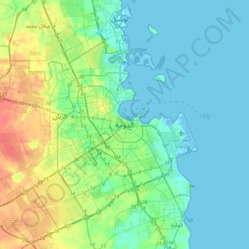
Name: Doha topographic map, elevation, terrain.
Location: Doha, Qatar (25.12563 51.36642 25.44563 51.68642)
Average elevation: 12 m
Minimum elevation: -3 m
Maximum elevation: 48 m
Make a donation
Gear up for your next adventure:
As an Amazon Associate, this site earns from qualifying purchases at no extra cost to you.