
Schneverdingen topographic map
Interactive map
Click on the map to display elevation.
About this map
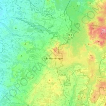
Name: Schneverdingen topographic map, elevation, terrain.
Location: Schneverdingen, Heidekreis, Nedersaksen, 29640, Duitsland (53.03234 9.62528 53.21946 9.93794)
Average elevation: 72 m
Minimum elevation: 36 m
Maximum elevation: 168 m
Other topographic maps
Click on a map to view its topography, its elevation and its terrain.
Wilseder Berg
Duitsland > Nedersaksen > Heidekreis > Niederhaverbeck
Wilseder Berg, Niederhaverbeck, Heidetal, Niederhaverbeck, Bispingen, Heidekreis, Nedersaksen, 29646, Duitsland
Average elevation: 125 m
Bad Fallingbostel
Duitsland > Nedersaksen > Heidekreis
Bad Fallingbostel, Heidekreis, Nedersaksen, 29683, Duitsland
Average elevation: 64 m