
Verl topographic map
Click on the map to display elevation.
About this map
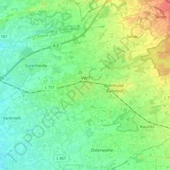
Name: Verl topographic map, elevation, terrain.
Location: Verl, Kreis Gütersloh, North Rhine-Westphalia, 33415, Germany (51.83104 8.44610 51.92646 8.60149)
Average elevation: 93 m
Minimum elevation: 79 m
Maximum elevation: 121 m
Other topographic maps
Click on a map to view its topography, its elevation and its terrain.
Emsquelle
Germany > North Rhine-Westphalia > Kreis Gütersloh > Schloß Holte-Stukenbrock
Average elevation: 135 m