
Kolašin topographic map
Interactive map
Click on the map to display elevation.
Kolašin
Kolašin is located on the foot of Bjelasica and Sinjajevina mountains, which offer great conditions for skiing. Because of Kolašin's altitude (954 m), the town is considered an air spa.
About this map
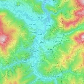
Name: Kolašin topographic map, elevation, terrain.
Location: Kolašin, Kolašin Municipality, 81210, Montenegro (42.78385 19.48180 42.86385 19.56180)
Average elevation: 1,133 m
Minimum elevation: 897 m
Maximum elevation: 1,669 m
Other topographic maps
Click on a map to view its topography, its elevation and its terrain.