
Lompre topographic map
Interactive map
Click on the map to display elevation.
About this map
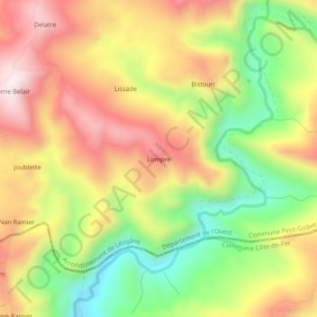
Name: Lompre topographic map, elevation, terrain.
Average elevation: 593 m
Minimum elevation: 270 m
Maximum elevation: 901 m
Other topographic maps
Click on a map to view its topography, its elevation and its terrain.
Besace
Haiti > West > Commune Petit-Goâve > Platon Besace
Besace, 9e des Palmes, Platon Besace, Commune Petit-Goâve, Arrondissement de Léogâne, West, Haiti
Average elevation: 851 m
Petit-Goâve
Haiti > West > Commune Petit-Goâve
Petit-Goâve, Commune Petit-Goâve, Arrondissement de Léogâne, West, 6220, Haiti
Average elevation: 100 m
Delatre
Haiti > West > Commune Petit-Goâve > Bistouri
Delatre, 8e des Platons, Bistouri, Commune Petit-Goâve, Arrondissement de Léogâne, West, Haiti
Average elevation: 717 m
11e Ravine Sèche
Haiti > West > Commune Petit-Goâve
11e Ravine Sèche, Commune Petit-Goâve, Arrondissement de Léogâne, West, 6220, Haiti
Average elevation: 511 m
6e Trou Canari
Haiti > West > Commune Petit-Goâve
6e Trou Canari, Commune Petit-Goâve, Arrondissement de Léogâne, West, Haiti
Average elevation: 750 m
12e des Fourques
Haiti > West > Commune Petit-Goâve
12e des Fourques, Commune Petit-Goâve, Arrondissement de Léogâne, West, Haiti
Average elevation: 431 m