
New York topographic map
Interactive map
Click on the map to display elevation.
About this map
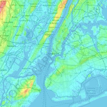
Name: New York topographic map, elevation, terrain.
Location: New York, New York County, New York, 10000, United States (40.55273 -74.16602 40.87273 -73.84602)
Average elevation: 15 m
Minimum elevation: -10 m
Maximum elevation: 186 m
The city's land has been altered substantially by human intervention, with considerable land reclamation along the waterfronts since Dutch colonial times; reclamation is most prominent in Lower Manhattan, with developments such as Battery Park City in the 1970s and 1980s. Some of the natural relief in topography has been evened out, especially in Manhattan.
Other topographic maps
Click on a map to view its topography, its elevation and its terrain.
Manhattan
United States > New York > New York County > New York
Manhattan, New York County, New York, United States
Average elevation: 16 m
Central Park
United States > New York > New York County > New York
Central Park, New York County, New York, United States
Average elevation: 26 m
Roosevelt Island
United States > New York > New York County > New York
Roosevelt Island, Manhattan, New York County, New York, 10044, United States
Average elevation: 13 m
Battery Park
United States > New York > New York County > New York
Battery Park, Manhattan Community Board 1, Manhattan, New York County, New York, 10004, United States
Average elevation: 3 m
Sara D. Roosevelt Park
United States > New York > New York County > New York
Sara D. Roosevelt Park, Lower East Side, Manhattan, New York County, New York, United States
Average elevation: 14 m
Brooklyn Bridge Park
United States > New York > New York County > New York
Brooklyn Bridge Park, Kings County, New York County, New York, 11201, United States
Average elevation: 9 m
Paley Park
United States > New York > New York County > New York
Paley Park, Midtown East, Manhattan, New York County, New York, 10022, United States
Average elevation: 24 m
Liberty Island
United States > New York > New York County > New York
Liberty Island, Manhattan Community Board 1, Manhattan, New York County, New York, Hudson County, New York, United States
Average elevation: 0 m
Riverside Park
United States > New York > New York County
Riverside Park, Manhattan, New York County, New York, United States
Average elevation: 17 m
Fort Tryon Park
United States > New York > New York County > New York
Fort Tryon Park, Manhattan, New York County, New York, United States
Average elevation: 20 m
Morningside Park
United States > New York > New York County > New York
Morningside Park, Morningside Heights, Manhattan, New York County, New York, United States
Average elevation: 20 m
Bennett Park
United States > New York > New York County > New York
Bennett Park, Hudson Heights, Manhattan, New York County, New York, United States
Average elevation: 24 m
Hunter’s Point South Waterfront Park
United States > New York > New York County > New York
Hunter’s Point South Waterfront Park, Manhattan Community Board 6, Manhattan, New York County, New York, United States
Average elevation: 5 m
Teardrop Park
United States > New York > New York County > New York
Teardrop Park, Manhattan Community Board 1, Manhattan, New York County, New York, United States
Average elevation: 6 m
Governors Island
United States > New York > New York County > New York
Governors Island, Manhattan, New York County, New York, United States
Average elevation: 1 m
Sherman Square
United States > New York > New York County > New York
Sherman Square, Manhattan Community Board 7, Manhattan, New York County, New York, United States
Average elevation: 22 m
Highbridge Park
United States > New York > New York County > New York
Highbridge Park, Manhattan, New York County, New York, United States
Average elevation: 30 m