Geolocate

Ubrug topographic map

Click on the map to display elevation.

About this map
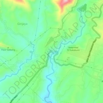
Name: Ubrug topographic map, elevation, terrain.

Location: Ubrug, Sukabumi, West Java, 43115, Indonesia (-6.97412 106.73072 -6.93412 106.77072)

Average elevation: 300 m

Minimum elevation: 220 m

Maximum elevation: 399 m

Other topographic maps

Click on a map to view its topography, its elevation and its terrain.

Situ Gunung

Indonesia > West Java > Sukabumi > Kadudampit

Average elevation: 1,039 m

Cibodas

Indonesia > West Java > Sukabumi > Cimenteng

Average elevation: 260 m

Cikahuripan

Indonesia > West Java > Sukabumi

Average elevation: 110 m

Cisolok

Indonesia > West Java > Sukabumi

Average elevation: 62 m

Gear up for your next adventure:

🧥Softshell Jackets - Breathable jackets for active outdoor use
📍Handheld GPS Navigators - Reliable satellite navigation for hiking and off-road exploration
🔦Waterproof LED Headlamps - Hands-free lighting for evening treks and emergency navigation
🍲Portable Camping Stoves - Fast-boiling stoves for hot meals on remote topographic survey trips
🥾Men's Waterproof Hiking Boots - Durable footwear with deep lugs for muddy and rocky UK terrains

As an Amazon Associate, this site earns from qualifying purchases at no extra cost to you.