
Make a donation
Gear up for your next adventure:
As an Amazon Associate, this site earns from qualifying purchases at no extra cost to you.
Niederrod topographic map
Click on the map to display elevation.
Make a donation
Gear up for your next adventure:
As an Amazon Associate, this site earns from qualifying purchases at no extra cost to you.
About this map
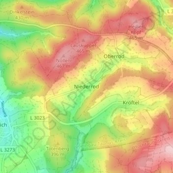
Name: Niederrod topographic map, elevation, terrain.
Average elevation: 392 m
Minimum elevation: 290 m
Maximum elevation: 483 m
Make a donation
Gear up for your next adventure:
As an Amazon Associate, this site earns from qualifying purchases at no extra cost to you.
Other topographic maps
Click on a map to view its topography, its elevation and its terrain.
Make a donation
Gear up for your next adventure:
As an Amazon Associate, this site earns from qualifying purchases at no extra cost to you.
Oberauroff
Deutschland > Hessen > Rheingau-Taunus-Kreis > Idstein > Oberauroff
Das Dorf liegt im Auroffer Grund am Auroffer Bach westlich der Kernstadt Idstein, von dieser durch einen Höhenrücken mit dem 403 Meter hohen Rügert und die Bundesautobahn 3 getrennt. Große Teile der Gemarkung sind bewaldet. Die nächstgelegenen Ortschaften neben der Kernstadt im Osten sind Niederauroff im…
Average elevation: 351 m
Make a donation
Gear up for your next adventure:
As an Amazon Associate, this site earns from qualifying purchases at no extra cost to you.