
Thank you for supporting this site ❤️
Make a donation
Make a donation
Gear up for your next adventure:
As an Amazon Associate, this site earns from qualifying purchases at no extra cost to you.
Tinyarumi topographic map
Click on the map to display elevation.
Thank you for supporting this site ❤️
Make a donation
Make a donation
Gear up for your next adventure:
As an Amazon Associate, this site earns from qualifying purchases at no extra cost to you.
About this map
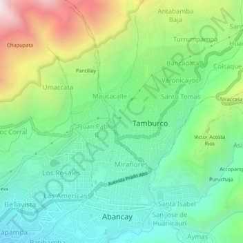
Name: Tinyarumi topographic map, elevation, terrain.
Location: Tinyarumi, Tamburco, Provincia de Abancay, Apurímac, Perú (-13.64172 -72.89816 -13.60172 -72.85816)
Average elevation: 2,678 m
Minimum elevation: 2,240 m
Maximum elevation: 3,613 m
Thank you for supporting this site ❤️
Make a donation
Make a donation
Gear up for your next adventure:
As an Amazon Associate, this site earns from qualifying purchases at no extra cost to you.