
Riedenheim topographic map
Interactive map
Click on the map to display elevation.
About this map
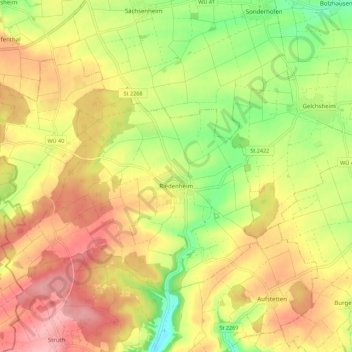
Name: Riedenheim topographic map, elevation, terrain.
Average elevation: 320 m
Minimum elevation: 253 m
Maximum elevation: 378 m
Other topographic maps
Click on a map to view its topography, its elevation and its terrain.
Stalldorf
Deutschland > Bayern > Landkreis Würzburg > Riedenheim > Stalldorf
Stalldorf, Riedenheim, Verwaltungsgemeinschaft Röttingen, Landkreis Würzburg, Bayern, 97283, Deutschland
Average elevation: 331 m