
Shimla topographic map
Click on the map to display elevation.
Shimla
Shimla is on the south-western ranges of the Himalayas at 31°37′N 77°06′E / 31.61°N 77.10°E / 31.61; 77.10. It has an average altitude of 2,206 metres (7,238 ft) above mean sea level and extends along a ridge with seven spurs. The city stretches nearly 9.2 kilometres (5.7 mi) from east to west.
About this map
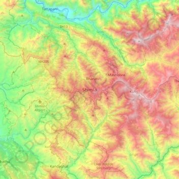
Name: Shimla topographic map, elevation, terrain.
Average elevation: 1,557 m
Minimum elevation: 618 m
Maximum elevation: 2,824 m
Other topographic maps
Click on a map to view its topography, its elevation and its terrain.
Shimla
Shimla is on the south-western ranges of the Himalayas at 31°37′N 77°06′E / 31.61°N 77.10°E / 31.61; 77.10. It has an average altitude of 2,206 metres (7,238 ft) above mean sea level and extends along a ridge with seven spurs. The city stretches nearly 9.2 kilometres (5.7 mi) from east to west.
Average elevation: 1,780 m
Shimla
Shimla district is one of the twelve districts of the state of Himachal Pradesh in northern India. Its headquarters is the state capital of Shimla. Neighbouring districts are Mandi and Kullu in the north, Kinnaur in the east, Uttarakhand in the southeast, Solan to the southwest and Sirmaur in the south. The…
Average elevation: 2,526 m
Lahaul and Spiti
Geologically located in the Himalayas and the Tibetan Plateau, Lahaul and Spiti district is connected to Manali through the Rohtang Pass. Kunzum la or the Kunzum Pass (altitude 4,551 m (14,931 ft)) is the entrance pass to the Spiti Valley from Lahaul. It is 21 km (13 mi) from Chandra Tal. To the south, Spiti…
Average elevation: 4,281 m
Bilaspur
The district lies in the outer foothills of the Himalayas, at the point where they meet the Punjab plains. There are no major mountains in the district, and the overall elevation isn't especially high, but the terrain is very hilly. Flat land is restricted to narrow areas along rivers and streams. The main…
Average elevation: 922 m
Una
The altitude varies from more than 409 meters in plains to over 1000 meters in hills. Swan River which is basically seasonal river and also known as soul of district Una flows 65 km right across the Jaswan Valley towards south until it submerges in the Sutlej river near Anandpur.
Average elevation: 533 m
Kangra
Dhauladhar Wildlife Sanctuary is located at an altitude of 1600 m going up to 4400 m, Dhauladhar Wildlife Sanctuary was established in 1994 by the Wildlife Department of Himachal Pradesh Government. It is situated in Kangra district. The wildlife sanctuary is covered by snow-clad mountains from three sides.…
Average elevation: 1,504 m
Hamirpur
Hamirpur district is situated between 31°25′N and 31°52′N and between 76°18′E and 76°44′E. Hamirpur (town), the district headquarters, is situated at an altitude of 780 m with the highest point being the Awah Devi peak at an altitude of 1250 m.
Average elevation: 759 m
Kinnaur
Kinnaur is an entirely mountainous district. The general altitude range is 1,500 metres above sea level to over 6,000 metres above sea level. The district is drained by several tributaries of the Sutlej river. Three mountain ranges run through or touch Kinnaur: the Zanskar range, the Great Himalaya range, and…
Average elevation: 4,232 m
Prashar Lake
India > Himachal Pradesh > Aut
Parashar Lake (also spelled Prashar Lake) is a freshwater lake located at an elevation of 2,730 metres (8,960 ft) in the Mandi district of Himachal Pradesh, India. It lies 12 km (7.5 mi) north of the town of Mandi, and has a three storied pagoda-like temple dedicated to the sage Parashara situated on its bank.…
Average elevation: 2,421 m
Nurpur
India > Himachal Pradesh > Nurpur
Nurpur is located at 32°18′N 75°54′E / 32.3°N 75.9°E / 32.3; 75.9. It has an average elevation of 643 metres (2109 feet).
Average elevation: 536 m