Geolocate

Buda topographic map

Click on the map to display elevation.

About this map

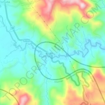
Name: Buda topographic map, elevation, terrain.

Location: Buda, Davao City, Davao Region, Philippines (7.49980 125.21666 7.53980 125.25666)

Average elevation: 976 m

Minimum elevation: 866 m

Maximum elevation: 1,208 m

Gear up for your next adventure:

📷Outdoor Action Cameras - Cameras designed for hiking and adventure
🧢Waterproof Hiking Hats - Keep the rain off your face while studying topographic maps
🧤Waterproof Overmitts - Extreme weather protection for hikers and mountaineers
❄️Walking Crampons - Added traction for icy slopes and winter peak bagging
🔋Power Banks - Portable chargers for long outdoor trips

As an Amazon Associate, this site earns from qualifying purchases at no extra cost to you.