
Make a donation
Gear up for your next adventure:
As an Amazon Associate, this site earns from qualifying purchases at no extra cost to you.
Diamondhead topographic map
Click on the map to display elevation.
Make a donation
Gear up for your next adventure:
As an Amazon Associate, this site earns from qualifying purchases at no extra cost to you.
Diamondhead
Much of the land that became Diamondhead had been purchased by Walter Gex Sr., in 1937 from the Gulf State Paper Company and the Easy Opener Bag Company. Additional land was purchased by Gex, bringing his acquisition to nearly 5,000 acres (2,000 ha). In the late 1960s, D.E.A.R., Inc., later known as the Diamondhead Corporation, a large corporation interested in resort developments, began operations on the Mississippi Coast, with Diamondhead as its first project. Coastal Mississippi had been a popular vacation destination for years, particularly with Midwesterners. Its location was ideal as a second home development given the convenient access via Interstate 55. The land on which Diamondhead is located is the highest point of elevation (100 feet (30 m) above sea level) on the Gulf Coast in Mississippi. Therefore, the project was named "Diamondhead" after Diamond Head, an iconic volcanic cone on the Hawaiian island of Oahu.
Make a donation
Gear up for your next adventure:
As an Amazon Associate, this site earns from qualifying purchases at no extra cost to you.
About this map
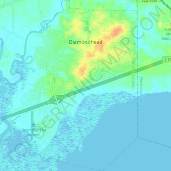
Name: Diamondhead topographic map, elevation, terrain.
Average elevation: 6 m
Minimum elevation: -4 m
Maximum elevation: 34 m
Make a donation
Gear up for your next adventure:
As an Amazon Associate, this site earns from qualifying purchases at no extra cost to you.