Geolocate

Pontedeume topographic map

Interactive map

Click on the map to display elevation.

About this map

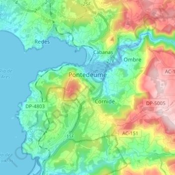
Name: Pontedeume topographic map, elevation, terrain.

Location: Pontedeume, O Eume, A Coruña, Galicia, Spain (43.37303 -8.22249 43.42843 -8.10022)

Average elevation: 116 m

Minimum elevation: -1 m

Maximum elevation: 405 m

Other topographic maps

Click on a map to view its topography, its elevation and its terrain.

A Capela

Spain > Galicia > O Eume

A Capela, O Eume, A Coruña, Galicia, 15613, Spain

Average elevation: 389 m

O Xestal

Spain > Galicia > O Eume

O Xestal, San Fiz de Monfero, Monfero, O Eume, A Coruña, Galicia, Spain

Average elevation: 351 m

Monfero

Spain > Galicia > O Eume

Monfero, O Eume, A Coruña, Galicia, Spain

Average elevation: 355 m

Os Gotes

Spain > Galicia > O Eume > Monfero

Os Gotes, San Fiz de Monfero, Monfero, O Eume, A Coruña, Galicia, 15619, Spain

Average elevation: 419 m