Geolocate

Albemarle topographic map

Click on the map to display elevation.

About this map

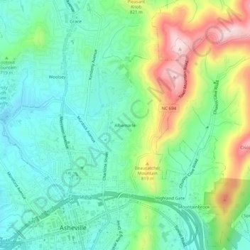
Name: Albemarle topographic map, elevation, terrain.

Location: Albemarle, Asheville, Buncombe County, North Carolina, 28802, United States (35.59150 -82.56263 35.63150 -82.52263)

Average elevation: 718 m

Minimum elevation: 616 m

Maximum elevation: 940 m

Other topographic maps

Click on a map to view its topography, its elevation and its terrain.

Gear up for your next adventure:

🧺Ultralight Dry Bags - Organize and waterproof your gear inside your rucksack
❄️Walking Crampons - Added traction for icy slopes and winter peak bagging
🔋Solar Chargers - Eco-friendly charging solutions for outdoor use
🎿Telescopic Trekking Poles - Reduces knee strain on steep topographic descents
📱Rugged Phone Cases - Heavy-duty protection for smartphones used as secondary GPS tools

As an Amazon Associate, this site earns from qualifying purchases at no extra cost to you.