
Scheßlitz topographic map
Interactive map
Click on the map to display elevation.
About this map
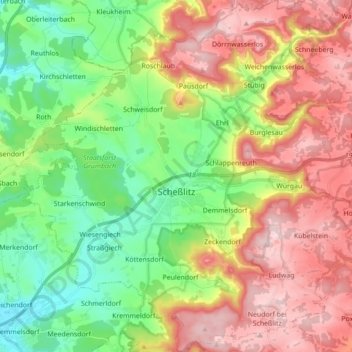
Name: Scheßlitz topographic map, elevation, terrain.
Location: Scheßlitz, Landkreis Bamberg, Bavaria, 96110, Germany (49.92579 10.95844 50.03801 11.12611)
Average elevation: 395 m
Minimum elevation: 254 m
Maximum elevation: 575 m
Other topographic maps
Click on a map to view its topography, its elevation and its terrain.
Wind
Germany > Bavaria > Landkreis Bamberg
Wind, Pommersfelden, Landkreis Bamberg, Bavaria, 96178, Germany
Average elevation: 284 m
Altendorf
Germany > Bavaria > Landkreis Bamberg
Altendorf, Landkreis Bamberg, Bavaria, 96146, Germany
Average elevation: 273 m
Stegaurach
Germany > Bavaria > Landkreis Bamberg
Stegaurach, Landkreis Bamberg, Bavaria, 96135, Germany
Average elevation: 289 m