
Thank you for supporting this site ❤️
Make a donation
Make a donation
Gear up for your next adventure:
As an Amazon Associate, this site earns from qualifying purchases at no extra cost to you.
Tongerlo topographic map
Click on the map to display elevation.
Thank you for supporting this site ❤️
Make a donation
Make a donation
Gear up for your next adventure:
As an Amazon Associate, this site earns from qualifying purchases at no extra cost to you.
About this map
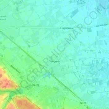
Name: Tongerlo topographic map, elevation, terrain.
Location: Tongerlo, Brée, Maaseik, Limbourg, Belgique (51.11551 5.64097 51.14586 5.71848)
Average elevation: 40 m
Minimum elevation: 30 m
Maximum elevation: 74 m
Thank you for supporting this site ❤️
Make a donation
Make a donation
Gear up for your next adventure:
As an Amazon Associate, this site earns from qualifying purchases at no extra cost to you.