
Altona-Nord topographic map
Interactive map
Click on the map to display elevation.
About this map
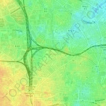
Name: Altona-Nord topographic map, elevation, terrain.
Location: Altona-Nord, Altona, Hamburg, 22769, Germany (53.55141 9.93222 53.57193 9.96050)
Average elevation: 24 m
Minimum elevation: 8 m
Maximum elevation: 39 m
Other topographic maps
Click on a map to view its topography, its elevation and its terrain.
Hamburg
The neighborhoods of Neuenfelde, Cranz, Francop and Finkenwerder are part of the Altes Land (old land) region, the largest contiguous fruit-producing region in Central Europe. Neugraben-Fischbek has Hamburg's highest elevation, the Hasselbrack at 116.2 metres (381 ft) AMSL. Hamburg borders the states of…
Average elevation: 23 m