
Turku topographic map
Click on the map to display elevation.
Turku
Operational since 1955, the city's weather station is located at an altitude of 47 metres (154 feet) at Turku Airport. The weather in the city itself is affected by the proximity of the sea, so the wintertime temperatures are often milder than those measured at the airport. The moderating impact of the sea helps oak maple and ash trees, which are quite rare elsewhere in Finland, to thrive by the areas along the shoreline and in the archipelago.
About this map
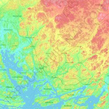
Name: Turku topographic map, elevation, terrain.
Average elevation: 32 m
Minimum elevation: -5 m
Maximum elevation: 95 m
Other topographic maps
Click on a map to view its topography, its elevation and its terrain.