
Les Hubert topographic map
Interactive map
Click on the map to display elevation.
About this map
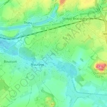
Name: Les Hubert topographic map, elevation, terrain.
Average elevation: 70 m
Minimum elevation: 40 m
Maximum elevation: 150 m
Other topographic maps
Click on a map to view its topography, its elevation and its terrain.
L'Avaleresse
Belgique > Hainaut > La Louvière > Strépy-Bracquegnies
L'Avaleresse, Strépy-Bracquegnies, La Louvière, Hainaut, Wallonie, 7100, Belgique
Average elevation: 86 m