Geolocate

Santa Rosa topographic map

Click on the map to display elevation.

About this map

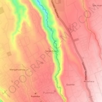
Name: Santa Rosa topographic map, elevation, terrain.

Location: Santa Rosa, Puembo, Quito Canton, Pichincha, 170907, Ecuador (-0.18132 -78.37699 -0.14132 -78.33699)

Average elevation: 2,408 m

Minimum elevation: 2,147 m

Maximum elevation: 2,506 m

Gear up for your next adventure:

🧤Hiking Gloves - Warm and durable gloves for cold-weather walks
📷Outdoor Action Cameras - Cameras designed for hiking and adventure
📱Rugged Phone Cases - Heavy-duty protection for smartphones used as secondary GPS tools
🧥Packable Down Jackets - Lightweight warmth that compresses small in your bag
👕Technical Hiking Tees - Moisture-management for high-exertion climbs

As an Amazon Associate, this site earns from qualifying purchases at no extra cost to you.