
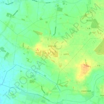
Joldelund topographic map
Interactive map
Click on the map to display elevation.
About this map
Name: Joldelund topographic map, elevation, terrain.
Average elevation: 16 m
Minimum elevation: 4 m
Maximum elevation: 34 m
Other topographic maps
Click on a map to view its topography, its elevation and its terrain.
Neukirchen
Deutschland > Schleswig-Holstein > Nordfriesland
Neukirchen, Südtondern, Nordfriesland, Schleswig-Holstein, 25927, Deutschland
Average elevation: 0 m
Welt
Deutschland > Schleswig-Holstein > Nordfriesland
Welt, Eiderstedt, Nordfriesland, Schleswig-Holstein, Deutschland
Average elevation: 0 m
Amrum
Deutschland > Schleswig-Holstein > Nordfriesland > Nebel
Amrum, Nebel, Föhr-Amrum, Nordfriesland, Schleswig-Holstein, 25946, Deutschland
Average elevation: 1 m