
Thank you for supporting this site ❤️
Make a donation
Make a donation
Gear up for your next adventure:
As an Amazon Associate, this site earns from qualifying purchases at no extra cost to you.
Hirzel topographic map
Click on the map to display elevation.
Thank you for supporting this site ❤️
Make a donation
Make a donation
Gear up for your next adventure:
As an Amazon Associate, this site earns from qualifying purchases at no extra cost to you.
About this map
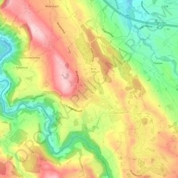
Name: Hirzel topographic map, elevation, terrain.
Location: Hirzel, Horgen, Bezirk Horgen, Zurich, 8810, Switzerland (47.19590 8.59018 47.23590 8.63018)
Average elevation: 647 m
Minimum elevation: 520 m
Maximum elevation: 769 m
Thank you for supporting this site ❤️
Make a donation
Make a donation
Gear up for your next adventure:
As an Amazon Associate, this site earns from qualifying purchases at no extra cost to you.