Geolocate

Malavalli topographic map

Click on the map to display elevation.

Malavalli

Malavalli town is located at 12°23′N 77°05′E / 12.38°N 77.08°E / 12.38; 77.08. It has an average elevation of 610 metres (2,000 ft).

Wikipedia (CC-BY-SA 3.0)

About this map

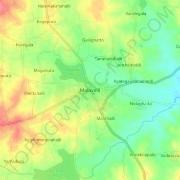
Name: Malavalli topographic map, elevation, terrain.

Location: Malavalli, Malavalli taluk, Mandya, Karnataka, 571430, India (12.34641 77.01895 12.42641 77.09895)

Average elevation: 630 m

Minimum elevation: 600 m

Maximum elevation: 670 m

Gear up for your next adventure:

🪓Outdoor Multitools - Versatile tools for hiking and camping
🐕Hiking Dog Harnesses - Rugged harnesses for taking your companion on mountain trails
🛌Sleeping Mats - Insulated mats for comfortable outdoor sleeping
🔋Rechargeable Batteries - Eco-friendly power for headlamps and older GPS units
🧢Waterproof Hiking Hats - Keep the rain off your face while studying topographic maps

As an Amazon Associate, this site earns from qualifying purchases at no extra cost to you.