Geolocate

St. Nicholas topographic map

Click on the map to display elevation.

About this map

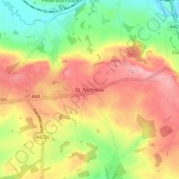
Name: St. Nicholas topographic map, elevation, terrain.

Location: St. Nicholas, Vale of Glamorgan, Wales, CF5 6SP, United Kingdom (51.44072 -3.33132 51.48072 -3.29132)

Average elevation: 79 m

Minimum elevation: 13 m

Maximum elevation: 138 m

Vale of Glamorgan trails, hiking, mountain biking, running and outdoor activities

Other topographic maps

Click on a map to view its topography, its elevation and its terrain.

Penarth

United Kingdom > Wales > Vale of Glamorgan

Average elevation: 17 m

Barry

United Kingdom > Wales > Vale of Glamorgan

Average elevation: 29 m

Dinas Powys

United Kingdom > Wales > Vale of Glamorgan

Average elevation: 30 m

St. Athan

United Kingdom > Wales > Vale of Glamorgan > St Athan

Average elevation: 30 m

Romilly Park

United Kingdom > Wales > Vale of Glamorgan > Barry

Average elevation: 26 m

Barry

United Kingdom > Wales > Vale of Glamorgan

Average elevation: 29 m

Barry

United Kingdom > Wales > Vale of Glamorgan

Average elevation: 29 m

Barry

United Kingdom > Wales > Vale of Glamorgan

Average elevation: 29 m

Gear up for your next adventure:

🎒Hiking Child Carriers - Explore the outdoors with the whole family safely
🧦Hiking Socks - Breathable socks designed to prevent blisters on long walks
🧰Survival Kits - Emergency tools for remote environments
🎒Hiking Daypacks - Compact backpacks ideal for short hikes and excursions
🔭Compact Hiking Binoculars - Lightweight optics for scouting terrain and spotting wildlife

As an Amazon Associate, this site earns from qualifying purchases at no extra cost to you.