Geolocate

Tlogo topographic map

Click on the map to display elevation.

About this map

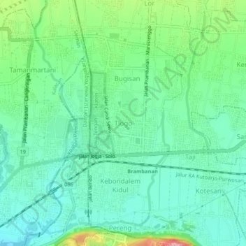
Name: Tlogo topographic map, elevation, terrain.

Location: Tlogo, Klaten, Central Java, Java, 57454, Indonesia (-7.76991 110.47721 -7.72991 110.51721)

Average elevation: 157 m

Minimum elevation: 120 m

Maximum elevation: 256 m

Other topographic maps

Click on a map to view its topography, its elevation and its terrain.

Sanggrahan

Indonesia > Central Java > Klaten

Average elevation: 150 m

Sungai

Indonesia > Central Java > Klaten > Nanggulan

Average elevation: 113 m

Gear up for your next adventure:

🥾Walking Shoes - Lightweight walking shoes for countryside and coastal paths
🧘Folding Sit Mats - Dry and warm seat for map-reading breaks on damp ground
🥾Trekking Poles - Poles to improve stability on uneven terrain
👖Hiking Trousers - Durable trousers designed for rough terrain
🧭Professional Hiking Compasses - High-precision liquid-filled compasses for map reading and orientation

As an Amazon Associate, this site earns from qualifying purchases at no extra cost to you.