Geolocate

Dover Base topographic map

Click on the map to display elevation.

About this map

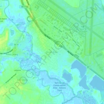
Name: Dover Base topographic map, elevation, terrain.

Location: Dover Base, Kent County, Delaware, 19902, United States (39.09855 -75.50335 39.13855 -75.46335)

Average elevation: 5 m

Minimum elevation: -7 m

Maximum elevation: 13 m

Other topographic maps

Click on a map to view its topography, its elevation and its terrain.

Bowers

United States > Delaware > Kent County

Average elevation: 0 m

Smyrna

United States > Delaware > Kent County

Average elevation: 10 m

Clayton

United States > Delaware > Kent County

Average elevation: 13 m

Dover

United States > Delaware > Kent County

Average elevation: 10 m

Magnolia

United States > Delaware > Kent County

Average elevation: 7 m

Dover

United States > Delaware > Kent County

Average elevation: 10 m

Harrington

United States > Delaware > Kent County

Average elevation: 17 m

Camden

United States > Delaware > Kent County

Average elevation: 13 m

Camden

United States > Delaware > Kent County

Average elevation: 13 m

Cheswold

United States > Delaware > Kent County > Cheswold

Average elevation: 13 m

Harrington

United States > Delaware > Kent County

Average elevation: 17 m

Cheswold

United States > Delaware > Kent County

Average elevation: 13 m

Lake Bernard

United States > Delaware > Kent County > Florence

Average elevation: 4 m

Gear up for your next adventure:

🪢Paracord - Multi-purpose cord for camping and survival
🎿Telescopic Trekking Poles - Reduces knee strain on steep topographic descents
📚UK Hiking Guidebooks - Detailed route descriptions for the Lake District, Peaks, and Highlands
🥾Walking Shoes - Lightweight walking shoes for countryside and coastal paths
🍳Camping Stoves - Compact stoves for outdoor cooking

As an Amazon Associate, this site earns from qualifying purchases at no extra cost to you.