
Providence topographic map
Click on the map to display elevation.
About this map
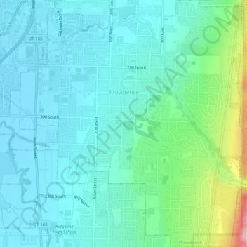
Name: Providence topographic map, elevation, terrain.
Location: Providence, Cache County, Utah, 84332, United States (41.68375 -111.83798 41.71962 -111.79411)
Average elevation: 1,434 m
Minimum elevation: 1,364 m
Maximum elevation: 1,728 m
Other topographic maps
Click on a map to view its topography, its elevation and its terrain.
Logan Canyon
United States > Utah > Cache County
Logan Canyon is a canyon in the western United States in northeastern Utah, which cuts its way through the Bear River Mountains, a branch of the Wasatch Range. It is popular for both summer and winter activities, especially rock-climbing, hiking, camping, fishing, snowmobiling, and skiing, at the Beaver…
Average elevation: 1,780 m