Geolocate

Sakleshpur topographic map

Click on the map to display elevation.

Sakleshpur

Sakleshpur is located at 12°53′35″N 75°43′30″E / 12.893°N 75.725°E / 12.893; 75.725. It has an average elevation of 932 m (3,058 ft) above mean sea level.

Wikipedia (CC-BY-SA 3.0)

About this map

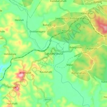
Name: Sakleshpur topographic map, elevation, terrain.

Location: Sakleshpur, Sakaleshapura taluk, Hassan, Karnataka, 573134, India (12.90343 75.74623 12.98343 75.82623)

Average elevation: 924 m

Minimum elevation: 856 m

Maximum elevation: 1,043 m

Gear up for your next adventure:

🕶️Glacier Goggles - Maximum protection for high-altitude snow topography
🥄Titanium Camping Sporks - The ultimate lightweight utensil for trail meals
🛰️Handheld GPS Devices - Reliable GPS units for hiking and outdoor navigation
👟Women's Trail Running Shoes - Agile footwear for fell running and technical trails
📸Action Camera Chest Mounts - Record your ascent following topographic paths hands-free

As an Amazon Associate, this site earns from qualifying purchases at no extra cost to you.